Please note: The Academy will close at 3 pm on Thursday, April 18, for Big Bang Gala.
Science News
Bienvenidos La Nina
June 29, 2010
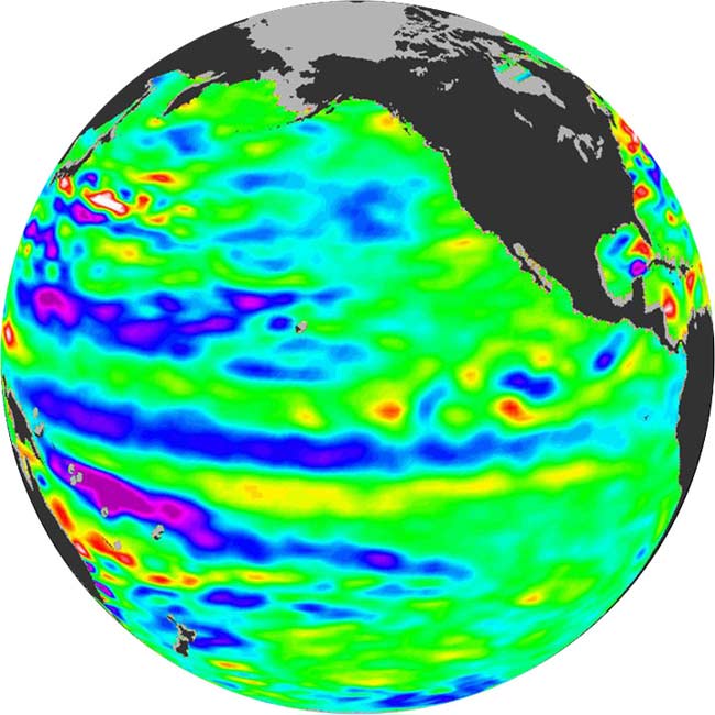
Looking at a satellite image from June 11th, last week NASA scientists announced that El Niño could be on its way out, with a predicted La Niña on its way. How do scientists read these images? Like tarot cards that predict weather patterns?
El Niño and La Niña both depend on ocean temperatures in the Pacific. The equatorial Pacific, specifically. If the temperatures are warmer than normal (based on averages from 1971-2000), that predicts a wet and warm El Niño pattern. If the temps are cooler, that means a colder, dryer La Niña is on its way.
And how is ocean temperature measured? By a satellite, of course. NASA’s Jason-2 satellite, where this image comes from, doesn’t measure temperature exactly, but measures sea surface height. Sea surface height is affected by both gravity and ocean circulation. Because gravity changes very little, the fluctuations in sea surface height are caused primarily by ocean circulation. The changing of the seasons, wind, warming and cooling all affect the circulation and therefore affect the height. According to NASA/JPL, “Using theory of ocean dynamics… sea-surface heights can be used to calculate how much heat is stored in the ocean below.”
Back to the image! The dark blue area in the center depicts the recent appearance of cold water hugging the equator, which the satellite measures as a region of lower-than-normal surface sea height. Voila La Niña.
“The next few months will reveal if the current cooling trend will eventually evolve into a long-lasting La Niña situation,” according to JPL oceanographer and climatologist Bill Patzert, PhD.
And that could be bad news for drought conditions in California and elsewhere. “For the American Southwest, La Niñas usually bring a dry winter, not good news for a region that has experienced normal rain and snowpack only once in the past five winters,” said Patzert.