Heads up: Plan for traffic and road closures this Sunday for Bay to Breakers.
Science News
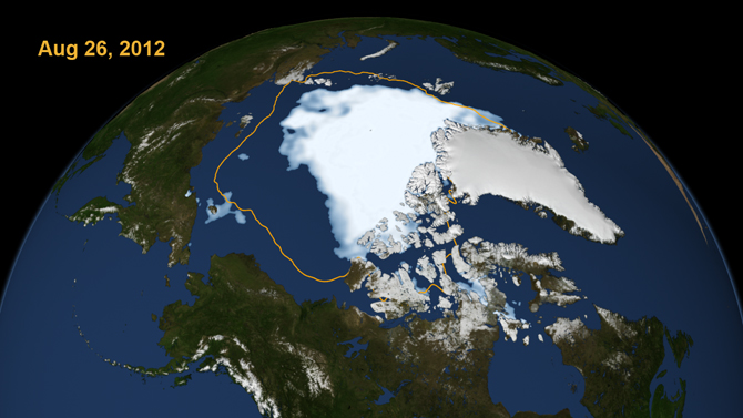
Arctic Sea Ice Record Low
August 28, 2012
A NASA/NSDIC (National Snow and Ice Data Center) press conference Monday announced a record low for the Arctic sea ice.
In the thirty years since consistent satellite observations of the polar cap began, August 26 displayed the lowest amount of sea ice extent—1.58 million square miles.
Unlike the last record low on September 18, 2007, this reduction has occurred much earlier in the summer and did not result from high temperatures.
The researchers say an Arctic storm earlier this month contributed to the reduced sea ice coverage. However, says NASA-Goddard’s Claire Parkinson, “the exact same storm a few decades ago would have been less impactful.”
Walt Meier of the NSDIC further explains that with less of the thicker, more resilient multi-year ice, the Arctic sea ice simply “could not take a punch.”
The sea ice cap naturally grows during the cold Arctic winters and shrinks when temperatures climb in the spring and summer. But over the last three decades, satellites have observed a 13% decline per decade in the minimum summertime extent of the sea ice. The thickness of the sea ice cover also continues to decline. According to Joey Comiso, senior research scientist at Goddard, this year saw a 19% decline in multi-year ice.
The 2007 “gigantic decrease,” as Parkinson describes it, stunned scientists, yet fortunately, in subsequent years the levels went up. But this year’s plummet is clearly the most dramatic on record, she says.
And the scientists all expressed concern that the sea ice could continue to melt over the next month as we approach the end of summer—potentially reducing it by another 150,000 square miles.
As Meier reiterated in a press release, “…in the context of what's happened in the last several years and throughout the satellite record, it's an indication that the Arctic sea ice cover is fundamentally changing.”
Image: Scientific Visualization Studio, NASA Goddard Space Flight Center